For departments of transportation, engineering firms, and municipal asset managers, getting accurate, timely data on roadway infrastructure has always been a painful trade-off between cost and speed. You either pay exorbitant amounts for a highly accurate physical survey, or you wait months for outdated imagery analysis.
That dynamic changes today. Blyncsy is thrilled to announce a significant collaboration with Google Geo, integrating Blyncsy’s Artificial Intelligence and asset analytics directly with the gold standard of global data: Google Street View imagery and its underlying LiDAR data assets.
This partnership is not just an integration; it’s a fundamental shift in how infrastructure assets are inventoried, maintained, and planned.
The Pain Point: High Costs and Slow Turnaround
Traditionally, if an engineering firm needed survey-grade measurements for a design project—say, the exact curb height, the precise distance to a street sign, or the width of a lane—they had to dispatch a specialized survey crew. This process involves high labor costs, expensive equipment, traffic disruption, and often takes months to schedule, execute, and deliver.
The Blyncsy + Google Solution: Data in Minutes, Costs Cut by 50%+
By coordinating with Google Geo, Blyncsy is now able to apply its AI models to the vast, high-resolution visual and 3D data collected by the Google Street View vehicles globally.
- Massive Cost Reduction: Traditional surveying can cost thousands of dollars per linear mile. Leveraging Google’s existing, massive, and continuously updated data collection network allows Blyncsy to deliver asset measurements and insights as a service for a fraction of that cost—we are forecasting cost reductions of 50% or more for many applications.
- Unprecedented Speed: The manual process of field data collection is eliminated. Instead of waiting months for a field survey team, engineers can access survey-grade asset measurements and insights directly through Blyncsy’s platform in minutes.
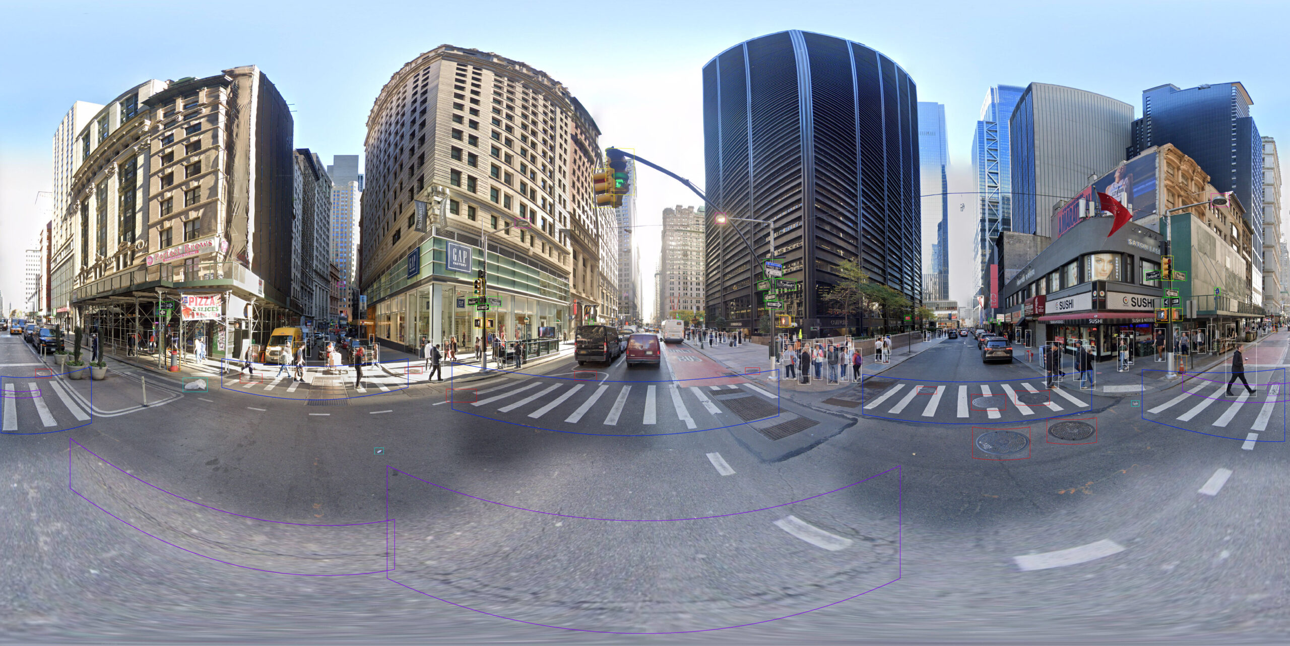
- Survey-Grade Measurements: Google Street View vehicles collect high-density LiDAR (Light Detection and Ranging) data in addition to the panoramic imagery. This LiDAR data provides the spatial accuracy—the “survey grade” precision—necessary for detailed engineering design, construction planning, and regulatory compliance, all delivered without ever sending someone out in the field.
A New Era for Engineering and Design
The implications for infrastructure engineering and design are massive. Design work is often stalled waiting for initial site measurements. With this collaboration, engineers can immediately pull accurate dimensions for:
- Design & Planning: Rapidly confirm right-of-way widths, pole locations, vertical clearances, and precise utility inventory before the first site visit.
- Asset Inventory: Automatically create and update highly accurate databases of signs, guardrails, traffic signals, and pavement markings across entire regions.
- Safety & Compliance: Instantly audit compliance with ADA requirements (curb ramps, sidewalk condition) or regulatory setback distances, ensuring projects meet safety standards from the start.
The Power of Historical Context and Global Scale
This collaboration enhances data integrity and availability in two powerful ways:
- Historical Analysis: Blyncsy can now run its AI analytics on older Street View data. This allows engineers to conduct historical asset condition and comparison—comparing the condition of a bridge railing or pavement three years ago to its current state today—which is invaluable for maintenance forecasting and litigation support.
- Increased Public Data Frequency: The partnership allows Blyncsy to work with Google to coordinate data collection globally. This collaboration will inherently increase the frequency with which Street View data is collected, providing fresher, more relevant data not only to Blyncsy’s customers but also to the public using Google Maps.
Complementary to Dashcam Analytics
This partnership is highly complimentary to Blyncsy’s existing core technology, which leverages crowd-sourced dashcam asset analytics. Our customers now benefit from three levels of infrastructure depth:
- Deep Accuracy (Street View + LiDAR): Provides the highest precision, survey-grade measurements and historical analysis for engineering and design.
- High Frequency (Dashcam Analytics): Provides near real-time monitoring for pavement condition, temporary debris, and immediate maintenance needs using daily driver footage.
- Comparative Insight: You can use the historical Street View data to measure what was, compare it against the current high-frequency dashcam view of the assets today, and confirm the precise dimensions required for design using the LiDAR-backed data.
This new collaboration with Google Geo establishes a new benchmark for infrastructure asset management—one that is faster, cheaper, more accurate, and globally scalable. The future of infrastructure management is no longer about sending crews out; it’s about pulling data in.