
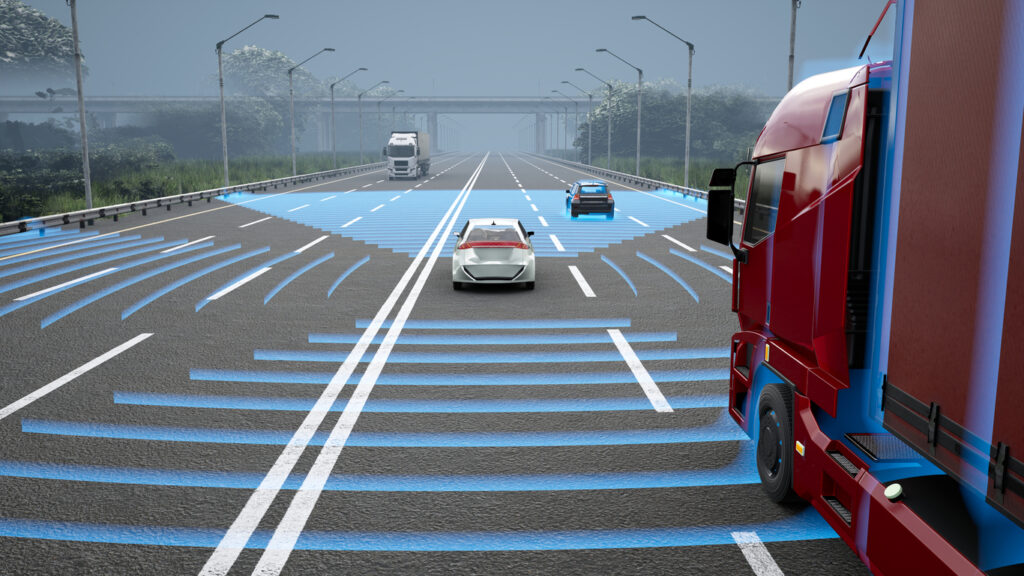
As Advanced Driver Assistant Systems (ADAS) become increasingly popular in newly manufactured vehicles, departments of transportation are increasingly looking to understand how their roadways have to adjust. Visibility for camera systems looking to assist with lane keeping, collision avoidance, and other features is crucial to ensure that these ADAS systems effectively lead to safer driving.
To better understand current capabilities and needs, the Connecticut Department of Transportation recently partnered with the University of Connecticut on a comprehensive study to determine “the type, width, materials, and maintenance intervals of lane marking improvements to meet the demands of automated vehicles in the future”.
This study, in turn, provides helpful information for an ongoing discussion point among departments of transportation across the country. Are vehicle cameras enough to evaluate the road conditions within our jurisdiction? Or are more comprehensive systems, like LiDAR, necessary to understand which conditions require follow-up action, repair, and replacement?
The answer, naturally, is complex. Transportation agencies need to find a balance between actionable results and scalability. While no single technology can help, AI image-based detection capabilities can go a long way toward implementing a successful process.
Key Findings From the Study
The study’s focus on pavement markings enables it to hone in on nuances from ADAS-equipped vehicles. These include width, retroreflectivity, contrast, and color. Its findings show where current systems work well to detect potential shortcomings in these areas, and where they may fall short:
- Retroreflectivity does not significantly impact ADAS lane marking detection. This finding suggests that measures of retroreflectivity don’t accurately predict visibility in real-world conditions. Retroreflectivity may still be important to comply with state and federal regulations. However, visibility measures can be used effectively for practical safety enhancements.
- Reliable lane predictions can occur below legal thresholds. Published by the U.S. Department of Transportation’s Manual on Uniform Traffic Control Devices, the minimum width of lane markings should be between four and six inches depending on the environment. The study, however, showed that ADAS can reliably detect markings as narrow as three inches, again showcasing its precision for real-world visibility.
- ADAS systems can struggle with some lane marking variances. The study particularly pointed out changes in marking color from yellow to white, the presence of objects on the road, and the lane’s width negatively impacting how ADAS could detect markings.
Due to these and other nuanced findings, the Ct DOT’s study concluded that while they are undoubtedly useful to everyday drivers, ADAS detection systems continue to have limitations that transportation agencies have to account for. Difficulty interpreting worn-out or damaged markings and road conditions, like construction zones and turns, require agency vigilance in maintaining safe roadways that go above and beyond these detection capabilities.
The Struggle of Accurately Assessing Road Conditions
Following regulations and keeping road infrastructure safe continues to be a struggle for transportation agencies across the country. That struggle begins with finding accurate and scalable ways to assess road conditions in a timely and cost-effective manner.
These conditions vary widely for individual states and even counties. At the same time, ADAS in new vehicles continues to become more common. This year, 10 of 14 driver assistance systems surpassed 50% in market share among new vehicles, with five surpassing 90%. Standardized road conditions are crucial to ensuring that this new generation of vehicles can continue to use the roads safely for everyone involved.
Manual surveys of road conditions and pavement markers are no longer enough in an environment dominated by machine detection. And yet, transportation agencies around the country are facing a fiscal cliff. This makes it difficult to implement extensive custom road surveys using technology like LiDAR. As crucial as consistent and comprehensive assessment may be, the solution is not easy to find.

How AI Image-Based Detection Can Help
The release of Connecticut DOT’s study suggests various ways technology may help agencies assess their road conditions. It also uncovers some limitations of those technologies. Ultimately, AI image-based detection and analysis can go a long way toward a solution that agencies of all sizes and budgets can leverage.
Consider these examples of the technology as related to the key insights from the study mentioned above:
- The ability of cameras to measure visibility beyond retroreflectivity means that visual analysis through dashcam footage can be practical and effective in understanding where markings may need urgent replacement based on real-world visibility.
- ADAS challenges to detect markings in events of color changes or the presence of objects on the road suggest that the more powerful ability of crowdsourced dashcam footage can provide more flexible, real-time data on road markings that can become more actionable for any repair or replacement plans.
Put differently, crowdsourced dash camera footage goes beyond the abilities of ADAS road detection in many ways. Its more adaptable and dynamic nature can identify lane markings and other measures of road conditions. Meanwhile, a wide network of dashcam sources allows for a more comprehensive analysis of road networks to build more comprehensive improvement plans.
At the same time, AI-enabled analysis does have some limitations that are important to consider. The images it sources cannot measure the strength of the pavement or asphalt, or the depth of a crack in the road. Its analysis is comprehensive but largely surface-level. It provides the baseline for your agency’s entire road network while some follow-ups may be necessary.

Building a Process to Benefit Your Agency
Monitoring and improving road conditions continue to be a priority for departments of transportation across the country. New and innovative ways to assess road infrastructure must be part of the equation. There is no silver bullet solution that can measure every nuance of every road within your jurisdiction at scale. But thanks to its high accuracy and scalability. Crowdsourced and AI-enabled dashcam footage analysis can provide the foundation for a more effective analysis and assessment system.
Through AI image-based detection, agencies can understand their road network and begin to build an improvement plan. More in-depth, specialized machinery that may be more expensive can then be used for targeted follow-ups only in the areas needed, with this more limited scope dramatically reducing budget investment in the process.
This more intentional process can go a long way toward preparing departments of transportation for the future. In terms of infrastructure and the vehicle technology for which future roads will need to account. With AI technology like Blyncsy as the core, agencies at every level can leverage more timely and cost-effective ways to optimize their operations.